
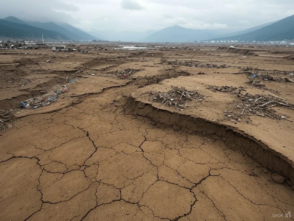
Xizang, China:
- Magnitude: 7.1
- Date and Time: January 07, 2025, at 06:35:18 IST (Indian Standard Time)
- Latitude: 28.86 N
- Longitude: 87.51 E
- Depth: 10km
- This region experienced a series of earthquakes, with magnitudes ranging from 4.7 to 7.1. These events were closely monitored due to the high magnitude of the primary quake.
- Magnitude: 4.9
- Date and Time: January 07, 2025, at 07:07:23 IST
- Latitude: 28.68 N
- Longitude: 87.54 E
- Depth: 30km
- Magnitude: 4.7
- Date and Time: January 07, 2025, at 07:02:07 IST
- Latitude: 28.60 N
- Longitude: 87.68 E
- Depth: 10km
- Magnitude: 4.8
- Date and Time: January 07, 2025, at 07:44:26 IST
- Latitude: 33.44 N
- Longitude: 87.58 E
- Depth: 10km
- Magnitude: 4.9
- Date and Time: January 06, 2025, at 20:56:47 IST
- Latitude: 33.64 N
- Longitude: 87.12 E
- Depth: 10km
Kangpokpi, Manipur, India:
- Magnitude: 3.6
- Date and Time: January 07, 2025, at 02:32:26 IST
- Latitude: 24.63 N
- Longitude: 94.19 E
- Depth: 10km
- This event was relatively smaller in magnitude but significant given the seismic activity in Northeast India.
Worldwide Overview:
- In addition to the above, global seismic activity included a magnitude 5.7 earthquake near Pagudpud, Philippines, and several smaller quakes across various regions. The USGS and other seismic networks continue to monitor these events to provide real-time updates and assess potential impacts.
Safety and Preparedness:
- For those in earthquake-prone areas, it’s advisable to follow safety protocols such as “Drop, Cover, and Hold On” during an earthquake, ensure emergency kits are ready, and stay informed through official channels or apps like BhooKamp for real-time earthquake information.
Please note that the information on earthquakes can change as more data is analyzed, and for the most current details, one should refer to official seismic data centers or use apps designed for earthquake alerts.
Seismic activity in India is significant due to its geographical location and tectonic setting. Here’s an overview based on the current available information:
Overview of Seismic Zones in India
India is divided into four seismic zones based on the Bureau of Indian Standards (BIS) seismic zoning map:
- Zone II: This is considered the least seismically active zone, covering approximately 41% of India’s landmass. It includes regions like the Karnataka Plateau and parts of the peninsular India.
- Zone III: A moderate damage risk zone, covering about 30% of the country. It includes states such as Kerala, Goa, and parts of Uttar Pradesh, Gujarat, and West Bengal among others.
- Zone IV: Classified as a high damage risk zone, covering 18% of India. Here, states like Jammu and Kashmir, Himachal Pradesh, Uttarakhand, and some parts of Delhi, Bihar, and Gujarat are included.
- Zone V: This is the highest seismic hazard zone, with 11% of India’s area, where the most intense earthquakes are expected. It encompasses the Himalayan region, northeastern states, the Rann of Kutch in Gujarat, and the Andaman & Nicobar Islands.
Recent Seismic Activity
- Today’s Activity: There has been a notable earthquake today in Kangpokpi, Manipur, with a magnitude of 3.6, indicating continued seismic activity in northeastern India.
- General Trends: India has had at least two quakes above magnitude 8 since 1900, suggesting that while larger earthquakes are infrequent, the potential exists. On average, India experiences about 792 quakes per year, with around 558 of magnitude 3 or higher.
- Notable Recent Events: Posts on X have indicated strong tremors felt in various regions of India, including Delhi NCR from earthquakes in neighboring countries like Nepal.
Geological and Tectonic Context
- Plate Tectonics: The seismic activity in India largely results from the northward movement of the Indian Plate, which collides with the Eurasian Plate, creating the Himalayan mountain range and associated fault systems like the Main Central Thrust and Main Boundary Thrust.
- Intraplate and Interplate: Earthquakes in India can be classified as interplate (occurring at plate boundaries, like in the Himalayas) or intraplate (within the Indian plate, like in Latur, Maharashtra).
- Vulnerability: Approximately 59% of India’s landmass is prone to earthquakes of various intensities, highlighting the need for seismic-resistant construction and disaster preparedness.
Preparedness and Mitigation
- Disaster Management: The Indian government, through agencies like the National Centre for Seismology and the National Disaster Management Authority, focuses on monitoring, early warning systems, and public education regarding earthquake preparedness.
- Building Codes: Structures in high-risk zones are supposed to adhere to stricter building codes for earthquake resistance.
- Public Awareness: Efforts are made to increase public awareness and readiness through drills, educational campaigns, and technology like earthquake warning apps.