Location: Satish Dhawan Space Centre, Sriharikota, IndiaAs the clock struck 5:40 PM IST on July 30, 2025, the skies over Sriharikota, India, lit up with a spectacle of human ingenuity and international collaboration.
The Indian Space Research Organisation (ISRO) successfully launched the Geosynchronous Satellite Launch Vehicle (GSLV-F16) carrying the NASA-ISRO Synthetic Aperture Radar (NISAR) satellite, marking a historic moment in space exploration.
This $1.5 billion joint mission with NASA not only signifies a technical triumph but also symbolizes a new era of global partnership in understanding and protecting our planet.
The images depict the rocket’s ascent, with flames and smoke illuminating the launch pad, followed by its graceful climb into orbit. This launch was no ordinary event—it marked the first time a GSLV rocket has placed a satellite into a sun-synchronous polar orbit, a challenging 743 km trajectory that allows NISAR to pass over the same areas of Earth at consistent times.
The precision of this feat is a testament to India’s decades-long journey in space technology, particularly after overcoming significant hurdles in the 1990s when the United States imposed sanctions, blocking access to cryogenic engine technology.
Undeterred, ISRO developed its indigenous CE-7.5 cryogenic engine, turning adversity into a source of national pride.The launch occurred just hours before midnight IST on July 30, with the satellite successfully injected into orbit 18 minutes later.
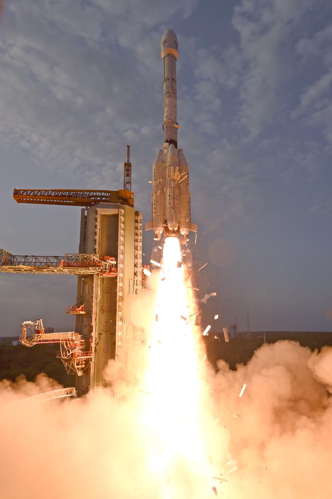
The post’s visuals—ranging from the rocket’s fiery departure to its ascent against a twilight sky—capture the awe-inspiring power and elegance of this mission, making it a moment of celebration for space enthusiasts worldwide.NISAR: A Technological MarvelAt the heart of this mission is NISAR, a 2,392 kg Earth-observing satellite designed to map the planet’s surface with unprecedented detail.
Equipped with dual-frequency radar—NASA’s L-band and ISRO’s S-band—NISAR uses advanced SweepSAR technology to scan Earth every 12 days. This dual-band capability, supported by a 12-meter deployable mesh antenna, allows the satellite to detect changes as small as a centimeter, penetrating clouds, smoke, and vegetation to provide all-weather, day-and-night imaging.
The mission’s scientific goals are vast, spanning six key areas: solid Earth processes (e.g., earthquakes and volcanoes), ecosystems, ice dynamics, coastal and ocean processes, disaster response, and additional applications like groundwater tracking and infrastructure monitoring. Pre-launch tests, detailed in a 2023 NASA Jet Propulsion Laboratory report, confirmed NISAR’s ability to deliver high-resolution data that will revolutionize our understanding of climate change, natural hazards, and resource management. From predicting landslides to monitoring glacier melt in the Himalayas, NISAR’s data will be a game-changer for scientists, policymakers, and communities globally.
A Decade of Collaboration Amid ChallengesThe NISAR mission is the culmination of a decade-long partnership between ISRO and NASA, formalized in 2014. This collaboration took on added significance during the COVID-19 pandemic, with 65 ISRO engineers working at NASA’s Jet Propulsion Laboratory (JPL) and 175 NASA engineers stationed at ISRO facilities.
This rare exchange of expertise contrasts sharply with the space race rivalries of the past, showcasing how international cooperation can drive innovation. The satellite’s development involved integrating NASA’s L-band radar and high-speed downlink systems with ISRO’s S-band radar, spacecraft bus, and launch vehicle, a fusion of technologies that required meticulous coordination.Delays, including a year-long pause to apply reflective coatings to NISAR’s radar reflector to prevent overheating, tested the patience of both agencies.
Yet, these challenges only strengthened the resolve to deliver a mission that promises to benefit not just India and the United States but the entire world. Union Minister Jitendra Singh hailed the launch as “India’s scientific handshake with the world,” a sentiment echoed in the global excitement surrounding NISAR.Open Data for a Global ImpactOne of NISAR’s most remarkable features is its open-data policy.
All observations will be freely available to the global scientific community within one to two days, with near real-time access during emergencies like natural disasters. This democratized access will empower developing nations, researchers, and disaster relief agencies, leveling the playing field in Earth observation. Over its five-year mission life, NISAR is expected to generate over 4,300 GB of data daily—enough to fill eight 512 GB laptops—offering a treasure trove of insights into our planet’s evolving landscape.Looking AheadAs of 06:36 AM IST on July 31, 2025, the mission is in its early orbit phase, with the next 90 days dedicated to in-orbit checkout and calibration.
Once fully operational, NISAR will circle Earth every 97 minutes, mapping nearly all land and ice-covered surfaces with a 242 km swath. Its data will not only enhance disaster preparedness—such as predicting floods and volcanic eruptions—but also support sustainable agriculture and climate resilience, aligning with India’s growing role as a spacefaring nation.
The GSLV-F16/NISAR launch is more than a technical achievement; it’s a beacon of hope in an era of global challenges. As ISRO’s X post invites us to “catch the liftoff visuals,” it also inspires us to look forward to a future where space technology serves humanity’s greatest needs. Congratulations to ISRO, NASA, and the global team behind this milestone—here’s to the next chapter in our cosmic journey!
Livestreaming Link: https://youtube.com/live/OgC1MxtCwq4
For more information: https://isro.gov.in/Mission_GSLVF16_NISAR_Home.html